
WEBSITE CURRENTLY UNDER CONSTRUCTION

Welcome to GDS-UK Drone Services
Capture stunning aerial photos and videos using the latest technologiy with GDS-UK's professional drone services. Contact us today to see how we can support your aerial imaging requirements
Professional Drone Services in Swansea and Surrounding Areas
We are a leading drone provider based in Swansea, offering expert drone filming, photography, and mapping services to clients across the region.
Specializing in high-quality aerial imagery, our skilled team utilizes the latest drone technology to capture stunning visuals for a wide range of applications.
Whether you need detailed mapping or cinematic aerial shots, we provide tailored solutions to meet your unique needs. Trust us to deliver exceptional results with a commitment to safety, precision, and professionalism.


Unparalleled Aerial Perspectives
Capture your world from a whole new perspective with our professional drone photography services. Whether you're showcasing a stunning property, documenting an event, or creating dynamic marketing content, our high-quality aerial shots offer a unique and breathtaking view that stands out. Our experienced pilots use cutting-edge drones to deliver crystal-clear, stunning imagery that brings your vision to life. From expansive landscapes to intricate details, we provide a fresh angle that traditional photography simply can’t match. Elevate your project today and let us help you tell your story from the sky!
Unlock unparalleled accuracy and efficiency with our professional drone surveying services. Using advanced drone technology, we provide high-resolution aerial data that delivers precise topographic maps, 3D models, and measurements for a wide range of industries. Whether you’re in construction, agriculture, mining, or land development, our drones capture detailed, real-time data that streamlines your surveying process, reduces costs, and minimizes the risk of human error. With faster turnaround times and the ability to access hard-to-reach areas, our drone surveys offer a smarter, more effective solution to help you make informed decisions and stay ahead of the competition.
Image – Unparalleled Aerial Perspective

MUMBLES PIER

Mumbles Pier


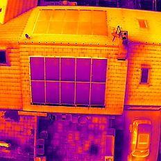
Insightful Aerial Insights
Experience the power of aerial insights with our Insightful Aerials service. By combining cutting-edge drone technology with advanced data analysis, we provide you with detailed, actionable insights from the sky. Whether you're monitoring construction progress, assessing environmental conditions, or tracking agricultural health, our aerial imagery and data help you make informed decisions with precision. We capture critical details from hard-to-reach areas, transforming complex data into clear, actionable visuals that save time, reduce risk, and enhance productivity. Get a bird’s-eye view of your projects and unlock a new level of insight to optimize your operations and strategies.
Case Studies
Mumbles Pier – We highly recommend Guardian Drone Services for their exceptional work in surveying our isolated lifeboat station after the recent storms. Their professional team utilized state-of-the-art drone technology to conduct a thorough and efficient assessment of the site, providing us with high-resolution aerial imagery and detailed data of the station's condition. The drone survey allowed us to quickly identify any storm damage, including hard-to-reach areas, ensuring a faster and more accurate response. Guardian Drone Services' expertise, reliability, and swift turnaround time were invaluable in helping us assess the situation and plan for necessary repairs, all while minimizing safety risks to our team. – B.Bollom Owner


Accreditations


